Kiribati
Micronesia Information
Nauru is situated in the middle of the vast Pacific Ocean, 60 kilometres to the south of the equator, at latitude 0°55’S and longitude 166°55’E. The island nation of Kiribati, comprising 33 atolls, straddles the equator, stretching 3235 kilometres across the Pacific Ocean.s.
March 7, 2017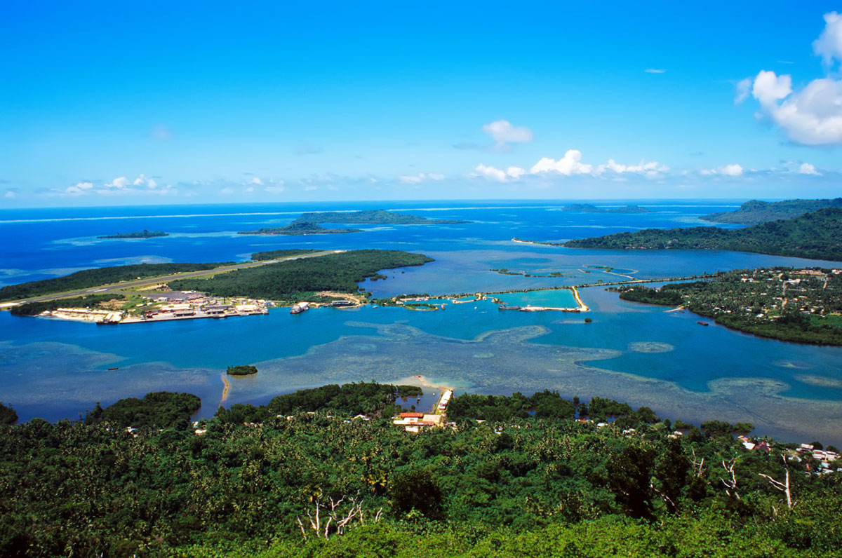
Pacific Island Living
March 7, 2017Micronesia
Nauru
General information
Nauru is situated in the middle of the vast Pacific Ocean, 60 kilometres to the south of the equator, at latitude 0°55’S and longitude 166°55’E. Six kilometres in length and four kilometres in width, its total area is 21.1 square kilometres, or 5,263 acres.
Its nearest neighbour is Banaba (also known as Ocean Island) in the Republic of Kiribati, 330 kilometres to the east. The coast of Papua New Guinea lies 2,150 kilometres to the south-west, Melbourne 4,705 kilometres to the south-west, Honolulu 4,457 kilometres to the north-west, Tokyo 4,797 kilometres to the north-west, Guam 2,827 kilometres to the north-west and Hong Kong 6,189 kilometres to the north-west, while Suva lies 2,324 kilometres to the south-east and Auckland 4,132 kilometres to the south.
The island is girdled with a 200 metres wide coral reef exposed at low tide. The coastal belt along the 19 kilometres circumference of the island and the small area surrounding the inland lagoon of Buada are most picturesque and fertile. Cultivation is limited to these areas where coconut palms and pandanus grow in abundance. Bananas and some vegetables are also produced in these areas. The top soil throughout Nauru is thin and porous, varying between 5cm and 30cm.
Beyond the coastal belt, the coral cliffs rise to heights up to 70 metres above sea level to form a vast plateau, generally referred to as “The Topside”. The area contains the only major land based economic resource of Nauru, the phosphate deposits, which cover nearly four-fifths of the country’s total land area. The phosphate is mined by open-cut method from amongst the tall coral limestone boulders, known as the pinnacles. The deposits vary in depth from eight to twenty-five metres, but they do not run deeper than sea level.
Phosphate rock
In 1900 Sir Albert Ellis, an Australian prospector, was intrigued when he came across a large block of rock used as a door stop. It was originally believed to be petrified wood, known to have come from “Pleasant Island” (Nauru). Intrigued, Sir Albert examined the piece scientifically and believed it was high quality phosphate. It was then taken to London where it was confirmed to be phosphate rock which led to the establishment of the phosphate mining industry in Nauru in 1907.
There are three principal theories about the origin of Nauruan phosphate. According to one theory, during the periods of submergence when the corals were building upwards over the volcanic platform, organic matter got entrapped amongst the limestone pinnacles and formed phosphate pellets. Subsequently, due to changes in the sea levels and tectonic uplifts, the island was raised above the sea level. According to a second theory, the phosphate is of igneous origin. The third theory suggests bird droppings formed guano over a long period of time. In the light of evidence from marine organic materials available at Topside, it would appear the theory of marine origin has greater credibility than others.
Whatever the origin, the Nauru rock is the purest in the world at 78% to 84% purity.
Flora & fauna
There are now about 200 species of flora, some 30 of which are indigenous including the coconut, banyan and almond trees, but unfortunately about 50 indigenous species appear to have become extinct due to phosphate mining. The fauna include about a dozen species of birds, the most important of which are the frigate bird (which features in the official emblem of the Republic), the white and black noddies, and the nightingale reed warbler known as the Nauruan canary whose delightful songs form the daily wake up call for Radio Nauru. Nauru has no indigenous animals.
Angam (means “coming home”)
On the 26th October 1932 the population touched 1,500 for the first time after the heavy toll influenza took soon after the First World War. Since then this day is celebrated as Angam Day. During the Second World War in June and July 1943, 1201 Nauruans were deported to the island of Truk in Micronesia. When the war ended in 1945 there were only 591 Nauruans on the island.
Of the 1,201 Nauruans sent to Truk, 464 died of starvation, disease and bombing; the 737 survivors returned to Nauru on 31st January, 1946. The population again touched the 1,500 mark on 31st March 1949. Nauru now has a population density of 381 per square kilometre.
Banking
Nauru uses the Australian dollar (AUD) as its currency. Australian notes and coins are the only cash able to be used on the island, as no facility exists for the exchange of foreign currency notes or travellers cheques to/from AUD.
Major international cards like MasterCard and Visa are not able to be used by visitors to Nauru for large-value purchases such as accommodation, rental cars and even shopping. Cash is widely used for such transactions, although internet banking can be used to make payments into bank accounts in Nauru or Australia to pay for these products and services.
The Bendigo Bank Agency is the only bank on Nauru, with a single presence at Civic Centre in Aiwo. ATMs are located at: Civic Centre (3) operating 24 X 7; Capelle Store (Ewa) Monday to Saturday during store hours; Menen Hotel.
While there are no exchange control restrictions between Nauru and Australia, it is necessary to declare $A10,000 or more in AUD or its equivalent in foreign currency cash being brought into Nauru. It is an offence to take more than AUD 2,500 or its equivalent out of Nauru without proper authority from the Revenue Office, and the completion of a Border Currency Report form is required if AUD10,000 or more is being taken out.
Public holidays
1st January – New Year’s Day
31st January – Independence Day
March/April – Good Friday, Easter Monday & Easter Tuesday
17th May – Constitution Day
1st July – Nauru Phosphate Corporation (NPC)
Handover Day (½ day)
26th October – Angam Day
25th December – Christmas Day
26th December – Boxing Day
Districts
Nauru has 14 districts, with no capital nor main town. If turning left from the airport (facing the runway), the districts are:
Yaren – home to the government offices and Parliament House.
Menen – Menen Hotel, The Reef Tavern, government departments and churches. Capital Cafe – only place to get a cappuccino on the island.
Anibare Bay – Swimming beach, main wharf
Ijuw – Local housing and small stores
Anabar – WW2 Japanese bunkers, Frigate bird cages (taboo for women – you must seek permission before visiting)
Anetan – Petrol station, local housing & swimming beach
Ewa – Capelle & Partner general store, cafe, rental apartments. Public toilets.
Baitsi, Uaboe, Nibok – local housing, Jules on the Deck restaurant, bar and nightclub. Surf beach.
Denig – Moon River Chinese Restaurant
Aiwo – Power station, wharf, phosphate factory, Odn Hotel, Civic Centre, Supermarket, Post Office, Cenpac internet cafe, Digicel & local restaurants, Bendigo Bank.
Buada – inland lagoon and local housing
Boe – airport, Reynaldo’s Chinese restaurant
Annual festivities
31st January – Independence Day Sports Carnival; Island beautification; wrestling
25th March – Nauru Congregational Church Youth Choral Competition
17th May – Women’s Fellowship Arts & Craft Exhibition. Constitution Day Sports Carnival
August – Nauru Arts Festival (2nd Saturday).
Kiribati
A welcome to Kiribati
The island nation of Kiribati, comprising 33 atolls, straddles the equator, stretching 3235 kilometres across the Pacific Ocean. With traditions and culture thriving and visitors regarded as a curiosity, it is the Pacific of yesteryear.
South Tarawa is the urban hub of the nation with a large concentration of the population crammed into rows of houses squeezed together.
Land is scarce here, the lagoon suffering under the weight of people, but this is where government and commercial activity is focused, where the hustle and bustle of Kiribati prevails.Venture away from south Tarawa and you escape this commotion, finding the unspoilt tranquillity of north Tarawa. To visit only south Tarawa is to miss the gentler side of Kiribati, the Kiribati where time flows with the moon and tides.
Located on Abatao in north Tarawa, our family homestay accommodation is delightful. The road halts abruptly at a passageway between the ocean and lagoon. A prompting whistle and a motorised canoe emerges from across the water to ferry us to the other side.
During the new moon, the crossing is magical as phosphorescence lights a trail behind us, swirling round our feet in the water; a step in the wet sand stirs a shower of phosphorescent dust.
Our guesthouse looks over the lagoon. A raised floor, roof of pandanus leaves and a mattress. Woven palm shutters keep out the rain, the lagoon breeze provides natural air conditioning! Home for a while. Privacy is pretty much non-existent but it all adds to the Kiribati charm.
It is quite normal to wake up, see several pairs of eyes staring back from beyond our feet, hear a shy ‘Mauri’ and then children running away giggling! The bathroom is shared and the toilet has built in entertainment as hermit crabs scurry around our feet.
Meals are local food; pancakes made with ‘toddy’ served with coconut syrup; fish, rice, breadfruit, pandanus and coconut. Sunset over the lagoon is spectacular with a ball of fire resting on the horizon, the sky blazing with shades of orange, red, pink, purple.
Serenity – apart from the lapping of the water on the lagoon edge and the distant crashing of waves on the ocean side. A receding evening tide brings fishermen into the lagoon, wading the shallows with the a lamp, trailing a fishing net between them or slowly drifting in a canoe to catch the next meal. In the dark of the night, tiny lights shine out in the middle of the lagoon.
Beyond the homestay, the village and North Tarawa stretch out. Traditional houses cluster together, a school, church, and a small shop, little else. Children line the street as we pass, quietly whispering or boldly shouting ‘I-Matang’ (foreigner) before running away.
Others crowd round in friendly curiosity, following until we reach the edge of the village or they lose interest. Beyond the village houses are sparsely spread along the track. I-Kiribati sit talking or carrying out daily chores; men climb trees for toddy; women sit weaving mats; children play, patiently practising skills passed down to them. There is no need here for TV or fancy toys – the children seem content with what their imagination and natural environment provide. Calm and tranquillity reign.
by Vanessa Nuttall.
Marhsall Islands
In recent history, the Marshalls and much of Micronesia was occupied by Germany until WWI, then Japan until their defeat in WWII. Thereafter the US took over, using the islands as a strategic base until their transition to ‘Free Association’ and renamed the country as Republic of the Marshall Islands (RMI). The US military still maintain a presence on Kwajalein.
Older Marshallese still remember the postwar atomic tests such as the famous ‘Bikini Atoll’ explosion, where an entire fleet of captured and retired warships was obliterated in a single blast. There is also a persistent, but lesser known story surrounding the disappearance of Amelia Earhart in 1938, which places her forced landing in the Marshalls.
Today leisure visitors arrive to enjoy spectacular sport fishing, amazing scuba diving and perhaps to explore the poignant war relics left behind after the fierce battle of WWII.
Where to stay
The major international airport is located on Majuro where the modern accommodation facilities are also to be found.
Hotel Robert Reimers
Operated by one of the pioneering Marshallese families, this property offers both standard hotel suites as well as secluded waterfront bungalows. There is a quality restaurant and bar located on-site and is well located, close to shopping and facilities. www.hotelrobertreimers.com
Airport Hotel and Lokjar Apartments
As the name suggests, located close to the airport and offering superior modern accommodation suitable for families or longer stay guests. Large, self-contained with reliable WiFi, these apartments are a popular choice.
Marshall Islands Resort
Located mid-island at Delop, this larger contemporary resort hotel offers guests familiar accommodation options found in many major islands with swimming pool, tennis courts and conference facilities. The full service restaurant and beachside BBQ are a local attractions. www.marshallislandsresort.com
Apart from these centrally located resorts and hotels, there are a great many basic beach ‘getaways’ to be found on the outer islands to suit backpackers and those seeking a more traditional island experience.
Eat and Drink
Majuro is quite the melting pot of international cuisine where visitors can find anything from Chinese, Filipino, Indian, French, Japanese and local Marshallese along the winding road from the airport to the Rita district at the island’s northernmost tip.
Enra
Located in the Marshall Islands Resort, the restaurant regularly offers themed cuisine in the large capacity restaurant and outdoor BBQ area.
Tide Table
Located in the Hotel Robert Reimers complex offering a wide range of Western and Asian themed dishes with a well stocked bar. Popular with travelling business people.
Getting around
Many locations can be reached on foot, but the local informal taxi service is both fun, economical and functional. Taxis stop to pick up passengers anywhere along their island-long route and will never cost more than a few dollars.
Otherwise a quality rental car is available from reliable operators like Majuro Motors nearby the Marshall Islands Resort.
Things to do
Scuba Diving
The RMI is fast gaining a reputation as a world-leading destination for adventurous scuba diving. With more than 1000 species of fish, 250 species of hard and soft corals as well as some of the most famous WWII shipwrecks (like the world’s only diveable aircraft carrier) it is truly for the most intrepid divers while still holding appeal for novices and snorkellers.
Surfing
Described by expert surfers as tropical cocktail mix of Hawaii and Indonesia and a delightful relaxing location to boot. For the technical, the majority of surf is right-handed point reef breaks that attract surfers between the ideal season of November to March when a lazy 10 knot breeze blows all day long.
Deep Sea and Lagoon Fishing
There is fishing for everyone in the RMI. Whether you are a deep sea fisher looking for the trophy pelagic bill fish or just some more leisurely lagoon species, fishing is an exciting activity the whole family can enjoy.
For the serious anglers, as many as ten tournaments are held every year. Day charters and excursions can be booked on a wide variety of vessels. Best time for fishing is May to October.
For more information on RMI activities, see www.visitmarshallislands.com
© 2025 Pacific Island Living Magazine all Rights Reserved
Website by Power Marketing